Muy a pesar de que todo el mundo cree que La Paz es la capital de Bolivia, esta es tan solo la sede del gobierno nacional, cuando el título oficial de capital según la Constitución Política del Estado le corresponde a Sucre. Prolija por donde se la mire, con sus construcciones de estilo colonial y sus prolijos parques, Sucre merece ampliamente el titulo que se le otorga. Sus calles angostas nos conducen a través de arcos que nos introducen en la zona céntrica histórica.
Plaza de Sucre
Su plaza, es por mucho la más prolija de toda Bolivia. Arreglos florales en todos sus parques, el césped completamente cuidado y monumentos limpios y sin grafitis le dan color al ya colorido que otorgan sus pobladores caminando por los senderos. Era sábado por la noche y queríamos descansar ya que los domingos, a escasos 65km se realiza una de las ferias-mercado más típicas e ancestrales de Bolivia, en la ciudad de Tarabuco, y claro está, no nos lo íbamos a perder.
Cultura Yampara
Dos horas sobre pequeños autobuses depositan a la gente en esta pequeña ciudad donde los lugareños compran provisiones y los turistas artesanías a por doquier. Alrededor de la plaza y en las calles aledañas se desparraman cientos de puestos con los más variados productos. Desde gorros, mantas y guantes de alpaca, hasta picos y palas, pasando por frutas, verduras y carne. Esta pequeña ciudad fue hace miles de años habitada por la cultura Yampara, a quienes aun hoy se los ve por las calles de Tarabuco, con sus cascos típicos y grandes ponchos de colores.
El tiempo nos perseguía de cerca, y luego de visitar una exposición de arte boliviano y deleitarnos con algunos bailes típicos en los cuales incluso Valeria tomo parte, retornamos a Sucre para no perder nuestro micro a Santa Cruz.
Comiendo en Tarabuco
Con ganas de recorrer la capital boliviana con más tiempo y conocer más sus suburbios, dejamos Sucre para dirigirnos a Santa Cruz a visitar a mis tíos, primos y ahijado. Nos esperaban aires de descanso en una casa de verdad, con camas de verdad y duchas 100% reales.
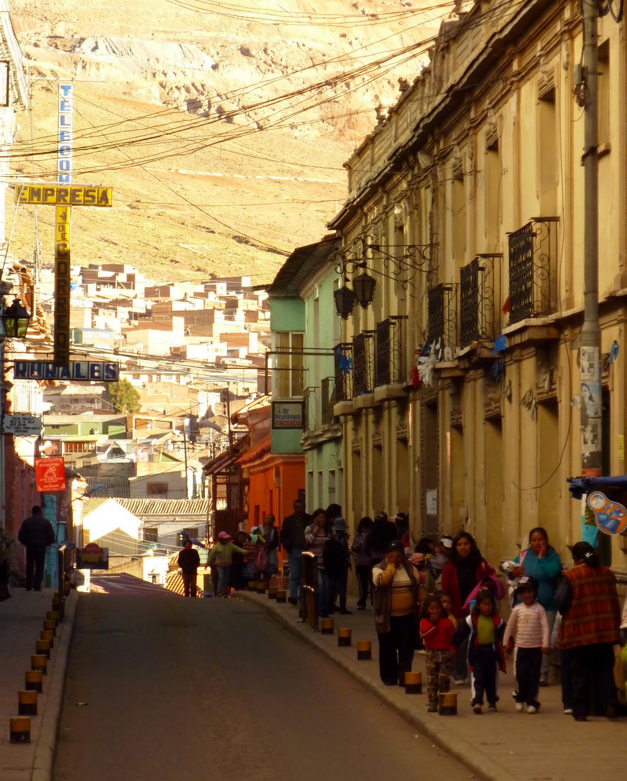
Cerca de las seis de la tarde llegamos a Potosí, la tercer ciudad más alta del mundo. Con sus más de 4000 m.s.n.m., Potosí deja sin aliento a cuanto gringo ose por trepar sus calles. Enormes portales de madera remachada, gigantescos muros de piedra e infinidad de colores en las vestimentas de sus mujeres, otorgan al lugar una mixtura de historia con actualidad difícil de explicar. Callejones de no más de 3mts de ancho zigzaguean por la ciudad trazando laberintos que no hacen más que confundir a los turistas, aunque su solo transito ya nos introduce en un mundo diferente, sin importar demasiado a donde nos termine depositando.
Calles de Potosi
Nos acomodamos en lo que creo debe ser uno de los peores 3 o 4 hostales de Potosí; el hostal La Paz. Lo único bueno era la ubicación y que las habitaciones eran privadas, porque el aspecto de sus patios, el continuo llanto de niños y el insoportable olor a humedad mezclado con insecticida hacían dudar si los $Bs 25 que pagamos no serian mucho para lo complicada que se veía venir la noche. Los revoques de las paredes se caían con el sonido de los pasos sobre los pisos de madera deteriorados, y la cama con una mesita de madera a modo de escritorio a su lado me daba la sensación de que alguna vez un San Martin o algún Simón Bolívar habían escrito alguna que otra carta informando sobre sus movimientos de guerra.
Es increíble como esta ciudad que supo ser la más rica de toda América Latina, hoy apenas mantiene en pie sus antiguos edificios, sin ningún tipo de avance más que el del deterioro. Alcanza con sacar los autos de sus calles para retroceder cientos de años y colocarse entre colonizadores peleando por sus riquísimas minas de plata. Minas que visitamos para darnos cuenta que dentro de ellas, el tiempo realmente nunca avanzo, nunca trajo consigo ningún avance para hacer el trabajo más saludable, nunca le devolvió a los potosinos la riqueza que alguna vez ostentaban sus calles.
Mujeres Potosinas
Ingresamos por las minas del Rosario, dentro del famosísimo Cerro Rico. A más de 4500 m.s.n.m. los túneles dentro de la montaña se encuentran inundados de agua por las filtraciones de sus paredes y los rieles para los carros que sacan el mineral apenas si se sostienen con algunos ganchos. En las zonas donde el túnel es factible de un derrumbe, arcos de madera son emplazados para sostener las rocas, aunque en más de una ocasión observamos por sobre nuestras cabezas maderas quebradas esperando un mínimo empuje para precipitarse al suelo.
Callejones
Desde su fundación en el año 1545 los españoles obtenían todo el fruto de los minerales el cual era llevado directamente a Europa, pero de un tiempo hasta parte, las minas se convirtieron en cooperativas por lo que hay quienes son dueños de una cara del túnel y todos los beneficios que esta les brinde pasan directamente a el minero socio y sus súbditos. Aunque no es tan fácil llegar a ser socio. Primero se debe ser minero de la más baja categoría, adquirir experiencia, y con el paso de al menos unos 8 a 10 años, juntar el dinero para comprar una de las caras y comenzar a explotarla para su beneficio. Pero muy a pesar de lo que parece, las ganancias son mínimas y las condiciones… también. Descendimos 3 niveles (separados entre ellos por 50mts de roca), y el calor se torna casi insoportable. El aire escasea y mezclado con los gases de explosiones y movimiento del propio cerro hacen muy difícil respirar. Incluso parece como si juntásemos polvo en la garganta, por lo que estamos constantemente escupiendo, aunque no escupimos nada, ya que esta sensación es la que da el respirar azufre, plomo y cientos de sulfatos que invaden nuestros pulmones y los de quien ande por el lugar.
Mineros Inexpertos
Llegamos a una zona donde un grupo de personas estaban trabajando. Era una familia, con el padre y sus dos hijos (es muy común que se asocien entre familiares), y pudimos hablar un rato con ellos sobre inquietudes que teníamos.
-Y cuanto hace que trabajas en la mina? – pregunte a uno de los hijos.
-Ya 12 años – me respondió con firmeza demostrando ser un experimentado minero.
-Y cuantos años tenes? – pregunte intrigado.
-24!
Desde los doce que estaba inmerso en ese mundo subterráneo por más de 6 horas por día, sin luz, sin aire, sin agua, en condiciones inhumanas. Mi cabeza no podía entenderlo. Y menos lo entendí luego de que me explicasen la manera en la cual extraen el mineral. En algunos casos realizan detonaciones con dinamita, en otros utilizan un percutor neumático, pero en el 90% de las veces el trabajo es a mano. Resulta que al ser cooperativas, cada uno debe comprar sus materiales y tanto la dinamita como el aire de los compresores les son caros para su trabajo. Incluso los carros para transportar las rocas son empujados a mano, y en varios casos los túneles no poseen rieles o bien se encuentran en un túnel el cual no les pertenece y por no pagar por su uso a otros socios, prefieren cargarlos en sus espaldas en bolsones de hasta 100kg.
Minero con uno de los Bolsones de 100kg
Salimos de las minas indignados, sin entender cómo se puede trabajar de esta forma. Siendo cooperativas y trabajando como socios, como no poder al menos utilizar algún tipo de maquinaria para facilitar los movimientos. Era en vano buscarle soluciones.
Nos dirigimos a un ingenio, una planta separadora de minerales. Allí llegan los camiones con las rocas extraídas del Cerro Rico, las cuales son depositadas en un tambor giratorio que muele las piedras hasta transformarlas prácticamente en polvo. Luego, estas van pasando por una serie de piletas, las cuales con el aditamento de ciertos químicos, hacen flotar las partículas de plata, las cuales son empujadas por unas palas giratorias hacia otras piletas que se encuentran en el exterior. Desde ahí lo que queda es más fácil. Se echa el agua con los minerales sobre el piso mismo, dejando que el sol evapore el agua y se carga la plata con pala en bolsones para su posterior transporte.
Carros para extraer los Minerales
Y a donde funden la plata y la trabajan para realizar diferentes productos? Esa simple pregunta respondió todo. En Europa. Las cooperativas venden 8tn de piedra en apenas USD 500 a los ingenios, los cuales luego de separar los minerales venden a poco más toda la plata en polvo a Europa. Son ellos quienes la funden, la utilizan en fabricación de diferentes productos y la exportan a todo el mundo. Está claro dónde queda el gordo de la ganancia no? Ustedes saben cuánto sale una pulserita de plata? Después de esto no dan ganas de comprar ninguna cosa que sea de este asqueroso material plateado. Aunque pensándolo diferente, dejaríamos sin trabajo al 85% de Potosí.
Ingenios
Da mucha bronca que luego de tanta lucha para que los mineros creen cooperativas, ahora que lo logran sigan trabajando en las mismas condiciones que cientos de años atrás, sigan muriendo de las mismas enfermedades, sigan viviendo en la misma pobreza, y que el dinero siga quedando en las mismas manos. La única diferencia es que los potosinos ahora no se sienten explotados. Pero como explicarle a esta gente que los utilizan como esclavos para el provecho de otros, si desde los 12 años se ven inmersos en este sub-mundo irreal de riqueza, sin posibilidad de estudio para comprender que están siendo manipulados?
Cerro Rico
De esta manera dejamos Potosí y sus minas. Minas donde incluso trabajaron mujeres durante tres años mientras Bolivia estaba en guerra con el Paraguay y no había hombres para explotarlas. Minas insalubres donde sus obreros toman alcohol puro a 96 grados para soportar el encierro. Minas donde la gente no supera los 40 años de edad. Minas donde sin saberlo, son explotados desde niños todos los potosinos, engañados con que ahora trabajan para su propio beneficio. Minas asquerosas… minas de mierda…
The third country in our trip itinerary was Bolivia - the “wild, wild west”, the country where anything goes, according to Argentines.
Bolivian south is very similar to the north of Argentina in its nature, traditions and even ethnic population, so I didn't feel a strong difference when we were finally on the Bolivian side. The one thing that did strike me was the border itself. There are three different gateways through which one can get to the other side: one is through the immigration office, the other avoiding it (it is up to you to register, and enter the country legally), and the third one is through the walking contraband bridge.
"Contrabando de hormigas".
It is a shocking scene to observe hundreds of people (many women and mostly indigenous) rapidly shuffling across the bridge with cargo twice their weight tied onto their backs. They carry goods from the Argentine side to the Bolivian side as fast as they can, then run back to the Argentine border to repeat it all over again. These people are contracted for a meager pay per trip to transport merchandise on their backs so that the owners of the cargo don’t have to pay foreign taxes. There is a law, according to which you can bring as many goods into the country as you can physically carry. So, this is the loop hole that is used and abused right in front of the customs officials 24/7! Hundreds of trucks arrive to the boarder daily, unload their cargo, send it to the other side on people’s backs, and load it back up to then continue the trip. It is obvious that these kinds of things happen on every border in Latin America, but seeing it with your own eyes shocks…
Salt and more salt...at teh Salar de Uyuni.
Anyways, having crossed the border (choosing the immigration office option) we were in Villazon, Bolivia. As Villazon turned out to be a typical border town with dusty streets and shabby looking constrictions, we decided to get on the first available train to the mythical Salar de Uyuni (12 hours away).
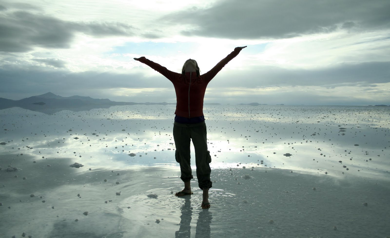
The Salar de Uyuni is the largest salt flat in the world covering 10,582 square kilometers. About 40,000 years ago this salar was covered by a prehistoric lake Minchin. When it eventually dried out it became an endless white salt desert, which supposedly grows larger and deeper with every year. According to our guide Juan, in the deepest part of the desert, the layer of salt reaches down to 14 meters (20 meters according to Wikipedia). Salar de Uyuni is located in the Oruro and Potosi departments of the country, which are a part of the Bolivia Altiplano or high plateau, a part of the country with very little population and unbelievable natural beauty. The Salar de Uyuni is surrounded by a number of other deserts, which in their turn are surrounded by mountains with peaks above 4,000 meters.
Surreal!
I have never heard about this place until I met Emi, whose Facebook profile photo was taken in the Salar de Uyuni. Apparently, this natural wonderland is becoming popular at the speed of geometrical proportion. Ten years ago this salar received about 9,000 visitors, and now this number is up to 70,000. Even though the place is becoming more and more touristy, and there are gringos from all over the world on every corner in the village of Uyuni, this adventure excursion doesn’t lose its attraction. If you are looking to see some mind blowing landscapes, have some Latin American adventure on a limited budget, and disconnect from the modern developed world you must come to the Bolivian Altiplano. You will have something to remember!
This world is amazing!
From all of the places I have been to in the world so far, this was the most different and breathtaking place I have seen. With a little bit of water on the surface, the salt transforms into a perfect mirror reflecting the sky. The sensation is absolutely surreal when you feel as if you are floating in the clouds, as you can’t tell where the earth ends and the sky begins. Looking through the windshield of our SUV I saw no horizon, and it felt as if we were driving directly into the clouds!
Just another lunch spot...
As most other seas, this sea also has islands above its surface. We stopped for lunch at one of them, Incahuasi or the Fish Island, during our first day of the trip. The coral island covered by enormous cacti (some 1000 years old) is not only gorgeous by itself, but also offers a panoramic 360% view of the whole salar. I felt as if I was on another planet, or in some parallel reality where laws of physics did not apply. Looking all around I felt as if I was surrounded by a never ending ocean, but somehow it was white and solid. What also blew my mind in that virtual world, was that I could not trust my eyes. When we were on the way to the Fish Island, I asked how far it was, expecting to hear that it was no farther than 10 minutes away (it looked like we were right next to it). The reply was that it was some 50 kilometers away, which took us about 40 minutes to cover. It felt as if the perfect white planes around played tricks on us. Somehow, everything appeared to be much closer, and moved much faster as it did in reality. It was INSANELY SURREAL…..!
Parallel worlds.
This time around, as we did not have our own transportation, and no funds to rent any, we joined a group of other 4 travelers and a local guide to take us to the salar and through the deserts of the Altiplano. It is absolutely worth doing it this way. You pay about $100 for 3 days of travel (close to 1000 km.) + all meals + lodging + a guide/driver! Nonetheless, we decided that the next time we do it (we are determined to return one day), we do it our own way and at our speed, stopping where we want, and staying the places we like for as long as we want. There were so many incredible spots where we wanted to stay and soak in the quiet beauty and peace, but we only had 3 days and a 1000 km to cover…
The train to nowhere.
The first day of the trip we spent crossing the salt desert. We left the town of Uyuni at about 9 am and had our first stop about 30 minutes later on the town outskirts at the steam train cemetery. The iron ruins of these once impressive machines are quite picturesque and are great for photo projects. Other than that, it is actually quite a sad seen, exhibiting little respect for the environment with trash of all sorts spread out in all directions. Garbage, and especially plastic waste is something that never stops shocking me wherever I go. Beverages and other products in plastic containers took over the world a long time ago, but it really feels like an invasion on the environment when you see those millions of plastic bags and bottles all over the ground in the developing countries…
Almost flying...
Why isn’t there a regulation for ANY-KIND-OF-COLA to build a plastic recycling plant for every soda plant that exists?! Besides, before selling their plastic crap, they should prepare the local population by educating them that plastic does not rot and decompose if you throw it on the ground, like they do with vegetable and animal waste. It takes 450-1000 years for a plastic bottle to break down , and about 500 years for a plastic bag (not even decompose)!!! Apparently, humans have never been environmentally conscious and always tossed they waste wherever they fancied. Well, it was not a big deal until it was all biodegradable…
A place to meditate and levitate.
By the end of our first day of the trip we reached the part of the salar which was still covered with water from the rainy season. Looking out of the window it felt that we were on a boat navigating and not driving in a car, especially when the water got deeper and we could hear the wake waves splashing as we passed. We were especially lucky to reach this part of the salar right when the sun was getting ready to set behind the horizon. The scenes we saw that night were impossible to describe… I can only say that it was probably the most memorable sunset I have seen in my life.
The "Rock Tree".
That night we were pleasantly surprised by our accommodations. We were supposed to stay in a group hostel, but because we reached it later that other travelers, it was full and we had to drive an extra hour to another village, where we were placed in one of the salt hotels. Not only that we had our own individual rooms, but we also actually had an opportunity to stay at a hotel completely made out of salt. Everything, from floors to beds and tables was made out of pure salt. It was especially fun to find all this salt useful at dinner time when I needed to spice up my food.
The "Red Lagoon".
The next day turned out to be a special day of adventure for Emi. In the morning, after about an hour of driving, our guide Juan confessed to us (only Emi and I could understand, as the rest did not speak Spanish) that he almost did not slep the night before and was not feeling too well. He told us that one of his relatives died in a mining accident that night, and so between the sorrow and the alcohol he almost did not catch a wink. We did not know whether to believe the story or not, but the part about being tired and hung over was true for sure, so very quickly it as decided to replace Juan with Emi as a driver. It was all fun and exciting, the only thing is that in some places there were no roads and we drove right in the middle of an open desert not knowing if we were going the right direction or not. Every so often Emi woke Juan up to check about directions, but every time the semi sleepy gesture directed us to go straight… We had to trust what he sad and continue towards the horizon. According to some rumors, a number of people got lost and died in those deserts trying to establish records by crossing them on foot. We were not on foot, but were still quite worried about getting lost. We had no GPS, maps were useless in places where there were no marked roads, and compasses do not work there (because of the magnetic minerals in the ground).
Flamingos.
By lunch time, after some hours of R&R, Juan was back on. Shockingly, we ended up at one of the lagoons we were told we were going to see. It was overcast that day and we thought that we were not going to be able to take photographs that do justice to the place. Nonetheless, by the time we reached the lagoon, the overcast turned into grayish-white dramatic cotton balls that sat on the mountain peaks. It was so beautiful that I wanted to run around, jump and scream to feel that it was real and I was not dreaming. And so I did! It was really fun and somehow liberating.
Salt roads.
In the afternoon there were more deserts, more lagoons and another sunset. I really have no words left to describe what we saw. You should just come and see it for yourself! That night our sleeping arrangements were a bit different and we all had to sleep in a dormitory with a straw ceiling. I had no problem with any of this, but our German companions freaked out and wanted to have Juan find as a different place. They read in their guide book that these straw roofs can sometimes have these insects “vinchucas”, and if bitten, you become sick with this lethal disease “chagas” which has no cure. It is true that this danger exists, but since all of the 70,000 tourists sleep in these places somehow it must be safe. Besides, there wasn´t much of a choice of hotels in the middle of a desert! Oh, those Germans!
Hot springs.
The next day, all safe and sound, first thing in the morning we went to take a dip in some hot springs. I was excited to finally experience hot springs as they come in nature. The place had a little shack/changing room, and nothing else except for a steaming hot beautiful lagoon surrounded by far away mountains. We played in the healing hot waters until Juan dragged us out, and packed us back into his car. We didn’t have much time because we had to get to the Chilean border to drop off Linda, one of the Swiss members of our crew. There, we learned that dropping someone off did not mean that we got to travel back to Uyuni (500 km) in more comfort. Very quickly Linda was replaced with 3, not exactly little, guys from England and Israel. With 8 of us in this “have seen it all” TOYOSA (Santa Cruz type of Toyota) ´96 SUV we started to head back.
Time to go back...
The one stop that impressed me that day was at the Red Lagoon. The water in that lagoon was really red! It is that color because of the algae that do photosynthesis in a particular way that turns them redish. It is quite strange to see red water, but it was not the water that made me want to stay there for much longer. Deep inside the lagoon there are hundreds and hundreds of pink flamingoes, which slowly walked in the water looking for the best place to feed. There are three kinds of South American flamingos: the Chilean, Andean and rare James's Flamingos. There are very few species left of these birds, the natural habitat of which is being continuously threatened by human activity.
Something is wrong with the horizon!
The places where we travelled in those tree days were not all protected lands, and only a part of these deserts is within a national park, but the rest can be cultivated, excavated and exploited in any other way. This whole part of Bolivia should be a protected area! That place is really a world treasure which will disappear unless something is done…
A number of hours later we were back in the village of Uyuni. It felt strange and abrupt to be back in “civilization”. I did not get enough of those deserts this time, so will have to come back…
The Argentine North is where you find “beautiful places with funny names”, as proclaimed my friend Vandria. From Cordoba we headed to Tafi del Valle, taking a quick detour in Tucuman, where Emi had to go see the city hall where the Argentine independence was proclaimed in 1916. The town of Tafi del Valle is a charming settlement in the middle of a green sleepy mountain valley. The climate and the scenery was very different from what we saw in Cordoba. It was colder, more humid and there was a lot more vegetation there. We did not do much in that town besides walking its streets and going up to the typical mountain with a cross. There is really nothing too special about the town, but it left such a pleasant feeling, that I would go back there in a heartbeat to get some of that calming, positive energy.
Tortilla, churros, tortilla....Anyone?
Out next stop was in Cafayate. Another valley town known for its white wines, mostly consumed in the province of Salta. We have no extra money to spend, but not when it comes to wine or cheese. Of course, I am talking about the level of “2 Buck Chuck” or “Vino Toro” level. Nonetheless, in Cafayate we got lucky and were able to raise the bar for only 5 pesos per person. We found an organic winery which gave a free tour and offered a rather generous wine tasting. The wines were absolutely delicious and it was hard to walk away without buying a bottle or two.
If you give us more food, we might give you more milk.
Feeling quite fulfilled and much happier we left the winery and set off to find a nearby cheese farm recommended to us at the hostel. It turned out that the farm was a side business to another winery, which decided to raise goats and cows for the manure necessary for the vineyards. I learned a bunch of peculiar facts about that whole operation. For example, I had no idea that grape seeds were very good for the animals because of their oils and vitamins, that goats gave 2 liters of milk per day and cows about 25, that the milking process had to be done when the animals were calm and happy and it only took about 3 minutes, and that most milk cows are now inseminated artificially and have to be given a bunch of hormones to conceive. It was really interesting to learn about animal maintenance and the actual cheese production, but it was even more exciting to find out that our tour ticket included cheese tasting and a whole wheel of goat cheese per person. We really lucked out with the treats that day! It was awesome!
Salt flats by Purmamarca.
From El Cafayate we went to Salta to visit more of Emi´s relatives. These relative were quite special, so I will skip this story here and tell you about them and the whole visit in a separate post.
The next destination after Salta was Purmamarca, or the famous “Hill of 7 Colors”. That village is really small, and appears to only have rudimentary adobe huts for the locals and amazingly beautiful 5 star hotels for the tourists. We lucked out with the only camping in the village for only 10 pesos per person. We arrived to the village in the afternoon, and since there was time and we had nothing better to do we decided to join a group of 3 other argentines and go on a tour of the nearby (1,5 hour by car) salt flats. Since it was my first experience with salt deserts, they made quite an impression on me. Besides the endless see of white saltiness, there were also lines of bright blue saltiness. They were artificial pools made for cultivation of salt (I think), which are great fun to play with. We took a bunch of photos there and even dipped our toes in the water besides the freezing temperature.
Around Tilcara.
It was much colder at the salt dessert that at Purmamarca because of the altitude. It was there when, for the first time, I began feeling that it was very hard to breath. On the way to these salt flats we passed a peek above 4,000 meters! They say that altitude makes you feel bad for a day or two and then you get used to. In my case it was not true and I only got worse the longer I staid high up. It took me a week or so to get over my sickness and get acclimated. I got better only once we finally crossed into Bolivia.
Purmamarca.
After a night in Purmamarca and a day of climbing all around the surrounding hills, which had more that 7 colors, we got on another bus and went to the town of Tilcara. There we found an awesome hostel with a huge very homey kitchen where I made my coffee cake featured in “Cosina Valeriano Vo. 5”. In Tilcara we went up to the “Devel’s Throat” canyon, walked around the surrounding villages, and then got on an afternoon bus to Humahuaca.
The colors of Purmamarca hills.
This northern town is known for its “folk music halls” peña called. Emi has been to one of those and was really excited to check it out again. To his great disappointment, the place, as well as half of the town, was shut down for the off season, so I couldn’t even take a peek to see what it looked like on the inside. Besides this little frustrating moment, we found the people to be very reserved and not even close to being friendly. The good thing was that we were in town for just one night. The reason why we went to Humahuaca, besides going to a peña, was to get a bus to the picturesque mountain settlement of Iruya.
Iruya (creacionymanifestacion.blogspot.com).
In reality, it is not the only village hidden away in those high mountain valleys, but it is only in Iruya that you get a welcome by an ancient, blue-domed church standing at the very entrance of the village. The landscape of the place is really unbelievable, with its steep mountain walls rising straight out of the river basin, which splits the village right in the middle. It is beautiful, but poor people who have to walk those vertical streets up and down every day! Our hostel, with no exception, was at the top of one of those streets. I thought I was going to die on the way to there when I had to carry my big backpack up that hill at the altitude of 2,780 meters and under burning mid day sun! On top of that, I was already sick with fever and headache and that up-hill stroll was not helping at all. I am not sure if it was the 3 hours of a dirt road, the altitude, or some weird bug but I was not feeling well and wanted nothing more than to lie down and close my eyes.
Cafayate streets.
I never fully recovered from my strange sickness in Iruya, but I did get a little better to be able to walk around and get inspired by the beauty of the place. We shared most our evenings at the hostel with 3 girls from Spain who were in Argentina on an exchange program. They were very fun and very Spanish, which made me miss my Spanish girls so much!!! It turned out that their next destination was the border town of La Quiaca, where I had to go get my Bolivian visa. We travelled there all together, and made more friends on the way. By the time we were looking for a hostel in Quiaca we were already 9! The more the merrier and that is exactly how it was that night. Between various Fernets we talked about everything from travel life to international politics, learned how to make macramé bracelets, and even shared some food, which we all made right in the room on our portable camping burners.
Purmamarca houses with funny corner doors.
In the morning, I was off to take care of my visa and Emi to meet up with Ramon and Celia, our first travel friends from Spain, with whom we shared some fun nights in Patagonia. They were on their way down to Buenos Aires and we made sure to coincide our border crossing with theirs, so that we could see them once again before they left for Spain. My visa did not take long, and after about an hour I could join Emi and the Spaniards for a quick catching up session outside our hostel. Unfortunately, none of us had much time so we had to say good bye and press on to the border. Bolivia was waiting for us…
Luego de casi dos meses y medio viajando, ingresábamos a nuestro tercer país en discordia; Bolivia. Apenas una corta caminata separa la ciudad de La Quiaca en Argentina, de Villazon, su hermana Boliviana; un largo trámite migratorio y un sello mas en las nuevas hojas de mi pasaporte recién renovado. Nuestro próximo destino era Uyuni, y nuestra escala fronteriza no sería más que la de algunas horas; las necesarias para esperar la partida del Wara Wara del Sur, uno de los pocos trenes aun activos en suelo boliviano.
Camenterio de Trenes
Unas 10 horas de viaje y ahí estábamos; ya en Uyuni, listos para preparar una expedición dentro de nuestra expedición. Esta sería de 3 días en donde recorreríamos casi 1000km atravesando desiertos, lagunas, montañas y lo más importante… el salar más grande del mundo. Nuestro medio de transporte seria una de las tantas Toyota Land Cruiser, un poco maltrecha, manejada por Juan, quien seria nuestro conductor y guía los próximos días. Los expedicionarios esta vez seriamos 6: dos alemanes, dos suizos y Valeriano. Las mochilas al techo de la vagoneta (como le dicen acá a las camionetas), y al fin partimos hacia la primer parada; el Cementerio de Trenes.
Ingresando al Salar de Uyuni
En un desolado campo, maquinas y vagones oxidados son el retrato de la decadencia de una ciudad que supo ser centro ferroviario minero de América y que hoy vive plenamente del turismo. La imagen, aunque absurda, es completamente extraña de ver. Esos gigantes metálicos de un color ladrillo por el maltrato de la herrumbre (que allí es más fuerte por la sal), yacen en medio de un panorama desértico a mas de 3600 m.s.n.m. Volvimos a la Toyota y continuamos viaje. A lo lejos se divisaba una línea blanca que al cabo de algunos minutos se ensanchaba más y mas, haciéndonos entrecerrar los ojos por el encandilamiento y el reflejo solar. Y de repente ahí estábamos… adentrándonos en el salar más grande del mundo; el Salar de Uyuni.
Desde la Isla Incahuasi
Con más de 12000km² y una llanura perfecta es imposible no sentirse disminuido ante semejante grandeza. La fina capa de agua depositada sobre la superficie en la temporada de lluvias forma un espejo natural que refleja el cielo de una manera exacta. Observas a tu alrededor y aun esforzando la vista se hace muy difícil encontrar el horizonte. Intentas con tu mirada abarcar todo, aunque todo es igual, todo es blanco, todo es cielo. De repente miras el suelo y te ves parado sobre una nube, la cual parece invitarte a caminar entre algodonosas formas flotantes. Los paisajes casi abstractos que se forman parecen ser pintados sobre una de sus partes, doblando el lienzo a la mitad para que se copie la otra en forma de espejo. Paisajes mudos y enceguecedores, infinito monologo de sal que impacta y confunde, que enamora y entristece, que tranquiliza y desespera.
Isla de Pescado
Mas de 80km recorrimos para llegar a la Isla Incahuasi, o Isla del Pescado, como se la conoce habitualmente por su forma similar a la de un pez. Este arrecifes de corales que alguna vez estuvo sumergido en aguas marinas, es hoy una protuberancia colmada de cactus que se eleva por sobre la plana superficie blanca. El contraste es altísimo y eso creo que es lo más importante para impactar al ojo humano. Contrastar plano con convexo, color blanco infinito con verdes y tierras, desierto con vegetación; esas conjugaciones prácticamente imposibles dejan a uno impactado, intentando retener e imaginar la causa de estos fenómenos naturales.
Atardecer en el Salar de Uyuni
Luego del almuerzo seguimos rumbo, quedando aun la parte más difícil de nuestro salado transito; salir del salar por su lado sur. Esta zona suele inundarse mucho e incluso hundirse ante el paso de los automóviles, por lo que son pocas las agencias que se atreven a enviar turistas por este lugar; pero por suerte, la nuestra lo hacía. El agua llegaba justo al límite con las puertas de la camioneta y ese mar extremadamente salado hasta formaba oleaje a nuestro paso y el del viento. El camino no existía, ni siquiera alguna huella ya que todo se encontraba bajo unos 50cm de agua, y tan solo el conocimiento de Juan nos llevaba hacia la salida. Mientras atardecía a nuestra derecha, dejamos atrás el salar y con algo de melancolía pensando que el tiempo nunca es suficiente en estos lugares, nos dirigimos al pueblo de San Juan, donde pasaríamos la primer noche dentro de un hotel de sal.
Saliendo del Salar
La mañana siguiente no iba a ser una mas y cuando estábamos cargando las mochilas, Juan me confesó un percance que le había sucedido a su familia, pero que a su vez llegaba indirectamente hacia nosotros. Su primo que trabajaba en Calama, había muerto esa misma noche en un accidente laboral y él había estado toda la noche sin dormir y bebiendo bastante para pasar ese mal trago; por consiguiente no sabíamos cuanto tiempo duraría despierto y sin salirse del camino. Comenzó a manejar y los cabezazos eran más potentes que los de Palermo en un Boca-River. Yo intentaba hablarle para distraerlo, pero siendo esta gente de no muchas palabras, rápidamente se me acababa el repertorio y otra vez comenzaba a pendular raudamente su cabeza. Pero por suerte aun quedaba algo de cordura en ese cerebro bamboleante y luego de aproximadamente una hora, me pidió si podía conducir.
Lagunas Altiplanicas
Así fue que atravesando el salar Chiguana y varios kilómetros desérticos conduje unas 2 o 3 horas hasta el mirador del Volcán Ollague, el cual hace de límite natural con la Republica de Chile. Más de una vez el camino se bifurcaba en varias direcciones, pero bastaba con un grito a Juan para que con un ademan me indicara por cual seguir. El camino continuaba costeando la Cordillera de los Andes, pasando por lagunas altiplánicas de los más variados colores y formas. El blanco en la Laguna Cañapa y Honda; los flamencos blancos y rosados en la Laguna Hedionda, sobrecargada de azufre; e infinitos espejos naturales en las Lagunas Verde y Colorada, las cuales yacen a los pies de enormes volcanes, entregando imágenes propias de un cuadro surrealista de Dalí.
Desierto Siloli
Por una de estas lagunas, la Colorada, se ingresa a la zona de la Reserva Nacional de Fauna Andina Eduardo Avaroa, ubicado al sudoeste del departamento de Potosí, en la provincia de Sud Lipez. A su vez, la reserva abarca parte del Desierto Siloli, el cual es considerado como fragmento del Desierto de Atacama; el más seco del mundo. En medio de este interminable manto de arena gruesa, una formación de piedra erosionada con forma de árbol (el Árbol de Piedra), yace casi inexplicablemente en forma vertical. Completamente inmune al paso del tiempo.
Desierto Siloli
El tercer día seria largo, ya que deberíamos recorrer la misma cantidad de kilómetros que habíamos hecho en los anteriores dos, ahora solo en uno. Con un Juan ya recuperado 100% de su sueño y demás, salimos en la mañana (después de varios problemas para poner en marcha la camioneta), hacia los géiseres Sol de Mañana. El zumbido del vapor emergiendo por debajo de la tierra era ensordecedor y las grandes nubes iluminadas por los primeros rayos tangenciales del sol, nos dan un paisaje bellísimo en medio del desierto boliviano. Pero más bello y relajante seria el posterior baño que tomaríamos en las aguas termales a orillas del Salar de Chalviri, donde no quedan dudas que el agua emerge de la tierra misma, de posibles corazones de volcanes enterrados bajo la planicie boliviana.
Geiseres
Quedaba lo más duro del viaje: la vuelta. Primeramente nos dirigimos hasta la frontera con Chile, para que Linda, la chica Suiza, hiciera su transfer y se dirigiera a San Pedro de Atacama. A escasos metros también está el límite con la Argentina, aunque allí no hay migraciones ni caminos, por lo que no es común el paso fronterizo a este último, pero si hacia el Océano Pacifico. Desde allí solo quedaba preparar el asiento lo mas mullido posible, un iPod con buena música, porque no un libro, y disponerse a esperar lo más relajados posible que terminen las últimas horas sobre la camioneta.
Sol de Maniana
Sera que el desierto me cautiva. Casi 1000km sin ver un solo árbol más que uno de piedra. Sin encontrar agua más que la de las lagunas, contaminadas de minerales volcánicos. Sin siquiera poder usar una brújula ya que el magnetismo del lugar hace que el norte este en todos lados… Lo dije la primera vez que conocí el altiplano boliviano, y lo vuelvo a repetir ahora luego de casi 5 años sin variar en lo más mínimo mis observaciones. El sudoeste de Bolivia sigue siendo el lugar más asombroso e increíble que he conocido. Ojala Valeriano me lleve a lugares aun más bellos, ya que si esto ocurre estaré en presencia de algo completamente asombroso.